Trail Running Longvilliers - Rochefort Denisy- St Martin de Brethencourt - Ste  Mesme - Dourdan -Bouc Étourdi - Rochefort  - Photo

Rochefort Denisy- St Martin de Brethencourt - Ste Mesme - Dourdan -Bouc Étourdi - Rochefort

© OpenStreetMap contributors
Length
Length
29 km
Max alt
Max alt
179 m
Uphill gradient
Uphill gradient
432 m
Km-Effort
Km-Effort  
35 km
Min alt
Min alt
93 m
Downhill gradient
Downhill gradient
439 m
Boucle
Boucle
No
Creation date :
2014-12-10 00:00:00.0
Updated on :
2014-12-10 00:00:00.0

(0 Reviews)

Running
Running
3h50
Difficulty : Difficult

Scan this QR Code to open this trail in the SityTrail application

FREE GPS app for hiking

Logo SityTrail SityTrail

IGN / Geographical institutes

Download SityTrail from the App Store Download SityTrail from Google Play

Logo SityTrail SityTrail World

The world is yours!

Download SityTrail from the App Store Download SityTrail from Google Play Download SityTrail on Huawei AppGallery

About

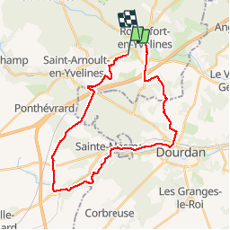
Trail Running of 29 km to be discovered at Ile-de-France, Yvelines, Longvilliers. This trail is proposed by Patrick_FAVE.

Description

Magnifiques paysages, on longe la rivière "L'Orge" de St Martin de Brethencourt jusqu'à Dourdan. Montées, faux-plats et chemins caillouteux amènent un peu de piquant dans les jambes. Le Hurepoix est magnifique.

Elevation profile

Positioning

Country:
France
Region :
Ile-de-France
Department/Province :
Yvelines
Municipality :
Longvilliers
Location:
Unknown
Start:(UTM)
424386 ; 5381033 (31U) N.

Trails nearby

Trail Walking Bonnelles - _Le rallye de Bonnelles à Rochefort - Photo
Walking
GUIDE+

Walking

Medium
(10)
Bonnelles, Ile-de-France, Yvelines, France
14.1 km | 16.4 km-effort
3h 30min
Yes
Trail Walking Longvilliers - _Les Moulins de la Rémarde - Photo
Walking
GUIDE+

Walking

Easy
(7)
Longvilliers, Ile-de-France, Yvelines, France
9.3 km | 10.4 km-effort
2h 0min
Yes
Trail Walking Clairefontaine-en-Yvelines - _Aux sources de la Rabette - Photo
Walking
GUIDE+

Walking

Easy
(15)
Clairefontaine-en-Yvelines, Ile-de-France, Yvelines, France
7.2 km | 8.3 km-effort
1h 51min
Yes
Trail Walking Bullion - _Le bois d''Haumont - Photo
Walking
GUIDE+

Walking

Easy
(4)
Bullion, Ile-de-France, Yvelines, France
5.8 km | 7.1 km-effort
1h 30min
Yes
Trail On foot Dourdan - Promenade de Nemours - Photo
On foot
PRO

On foot

Easy
Dourdan, Ile-de-France, Essonne, France
4.5 km | 4.9 km-effort
1h 6min
No
Trail Nordic walking Dourdan - Forêt de Saint Arnoult - Photo
Nordic walking
Zygomat

Nordic walking

Easy
(1)
Dourdan, Ile-de-France, Essonne, France
8.6 km | 10.5 km-effort
1h 50min
Yes
Trail Mountain bike Bonnelles - Bonnelle - Photo
Mountain bike
jfcontour

Mountain bike

Easy
(1)
Bonnelles, Ile-de-France, Yvelines, France
52 km | 61 km-effort
Unknown
Yes
Trail Walking Dourdan - Ste Mesme St Martin de Brethencourt - Photo
Walking
raivavae

Walking

Medium
(2)
Dourdan, Ile-de-France, Essonne, France
14.9 km | 17.5 km-effort
5min
Yes
Trail Walking Dourdan - R2-Dourdan et sa forêt - Photo
Walking
CSR-94

Walking

Very difficult
(1)
Dourdan, Ile-de-France, Essonne, France
19.3 km | 24 km-effort
5h 23min
Yes


Close
My subscriptions