


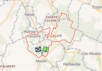
2018-11-15-maule-bazemont

Rando MLC
User

Length
17.4 km

Max alt
194 m

Uphill gradient
390 m
Km-Effort
23 km

Min alt
25 m

Downhill gradient
388 m
Boucle
Yes
Creation date :
2022-11-27 09:51:59.042
Updated on :
2025-01-04 11:32:33.43
5h08
Difficulty : Medium

FREE GPS app for hiking
 SityTrail
IGN / Geographical institutes
SityTrail Plus
The world is yours!
About
Trail Walking of 17.4 km to be discovered at Ile-de-France, Yvelines, Maule. This trail is proposed by Rando MLC.
Positioning
Country:
France
Region :
Ile-de-France
Department/Province :
Yvelines
Municipality :
Maule
Location:
Unknown
Start:(Dec)
Start:(UTM)
415849 ; 5418319 (31U) N.
Comments