


viala bas

tyntyn
User
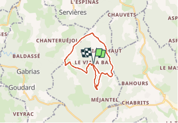

Length
12.8 km

Max alt
1187 m

Uphill gradient
449 m
Km-Effort
18.8 km

Min alt
882 m

Downhill gradient
454 m
Boucle
Yes
Creation date :
2022-11-28 15:00:46.021
Updated on :
2022-11-28 15:00:45.963
4h16
Difficulty : Medium

FREE GPS app for hiking
 SityTrail
IGN / Geographical institutes
SityTrail Plus
The world is yours!
About
Trail Walking of 12.8 km to be discovered at Occitania, Lozère, Barjac. This trail is proposed by tyntyn.
Positioning
Country:
France
Region :
Occitania
Department/Province :
Lozère
Municipality :
Barjac
Location:
Unknown
Start:(Dec)
Start:(UTM)
533284 ; 4932912 (31T) N.
Comments