


Lac de Graon Champs st Père

taguette
User
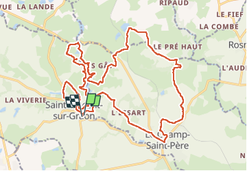

Length
27 km

Max alt
74 m

Uphill gradient
322 m
Km-Effort
31 km

Min alt
20 m

Downhill gradient
319 m
Boucle
Yes
Creation date :
2022-11-25 07:46:15.586
Updated on :
2022-11-28 16:31:51.413
5h42
Difficulty : Difficult

FREE GPS app for hiking
 SityTrail
IGN / Geographical institutes
SityTrail Plus
The world is yours!
About
Trail Walking of 27 km to be discovered at Pays de la Loire, Vendée, Saint-Vincent-sur-Graon. This trail is proposed by taguette.
Positioning
Country:
France
Region :
Pays de la Loire
Department/Province :
Vendée
Municipality :
Saint-Vincent-sur-Graon
Location:
Unknown
Start:(Dec)
Start:(UTM)
623698 ; 5152702 (30T) N.
Comments