


condé

LaurentBernard
User
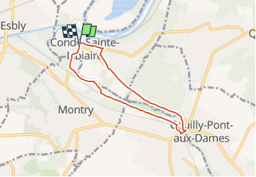

Length
5.7 km

Max alt
61 m

Uphill gradient
35 m
Km-Effort
6.2 km

Min alt
43 m

Downhill gradient
36 m
Boucle
Yes
Creation date :
2022-11-28 17:40:24.369
Updated on :
2022-11-28 17:41:20.413
1h24
Difficulty : Easy

FREE GPS app for hiking
 SityTrail
IGN / Geographical institutes
SityTrail Plus
The world is yours!
About
Trail On foot of 5.7 km to be discovered at Ile-de-France, Seine-et-Marne, Condé-Sainte-Libiaire. This trail is proposed by LaurentBernard.
Positioning
Country:
France
Region :
Ile-de-France
Department/Province :
Seine-et-Marne
Municipality :
Condé-Sainte-Libiaire
Location:
Unknown
Start:(Dec)
Start:(UTM)
487483 ; 5416084 (31U) N.
Comments