


Beau puy

Monique Aubry
User
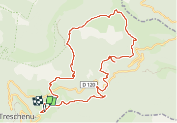

Length
13.1 km

Max alt
1743 m

Uphill gradient
930 m
Km-Effort
26 km

Min alt
878 m

Downhill gradient
929 m
Boucle
Yes
Creation date :
2022-11-25 08:08:23.0
Updated on :
2022-11-29 11:23:46.661
4h28
Difficulty : Unknown

FREE GPS app for hiking
 SityTrail
IGN / Geographical institutes
SityTrail Plus
The world is yours!
About
Trail Walking of 13.1 km to be discovered at Auvergne-Rhône-Alpes, Drôme, Châtillon-en-Diois. This trail is proposed by Monique Aubry.
Positioning
Country:
France
Region :
Auvergne-Rhône-Alpes
Department/Province :
Drôme
Municipality :
Châtillon-en-Diois
Location:
Treschenu-Creyers
Start:(Dec)
Start:(UTM)
702421 ; 4957135 (31T) N.
Comments