


2911

maxEA65
User
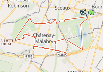

Length
12.4 km

Max alt
163 m

Uphill gradient
185 m
Km-Effort
14.9 km

Min alt
51 m

Downhill gradient
185 m
Boucle
Yes
Creation date :
2022-11-29 13:14:01.538
Updated on :
2022-11-29 15:55:58.379
2h41
Difficulty : Difficult

FREE GPS app for hiking
 SityTrail
IGN / Geographical institutes
SityTrail Plus
The world is yours!
About
Trail Walking of 12.4 km to be discovered at Ile-de-France, Hauts-de-Seine, Sceaux. This trail is proposed by maxEA65.
Positioning
Country:
France
Region :
Ile-de-France
Department/Province :
Hauts-de-Seine
Municipality :
Sceaux
Location:
Unknown
Start:(Dec)
Start:(UTM)
448836 ; 5402644 (31U) N.
Comments