


GR 10 02

chasle
User
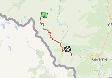

Length
14.4 km

Max alt
2738 m

Uphill gradient
789 m
Km-Effort
26 km

Min alt
1821 m

Downhill gradient
1039 m
Boucle
No
Creation date :
2022-11-29 18:11:52.397
Updated on :
2022-11-29 18:21:29.013
5h50
Difficulty : Difficult

FREE GPS app for hiking
 SityTrail
IGN / Geographical institutes
SityTrail Plus
The world is yours!
About
Trail Walking of 14.4 km to be discovered at Occitania, Hautespyrenees, Cauterets. This trail is proposed by chasle.
Positioning
Country:
France
Region :
Occitania
Department/Province :
Hautespyrenees
Municipality :
Cauterets
Location:
Unknown
Start:(Dec)
Start:(UTM)
733811 ; 4741769 (30T) N.
Comments