


GR 10 12

chasle
User
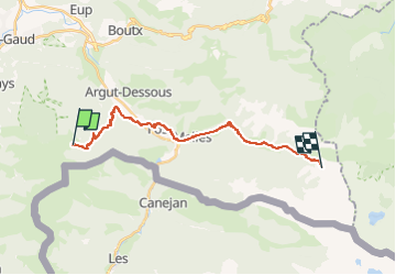

Length
20 km

Max alt
1863 m

Uphill gradient
1506 m
Km-Effort
39 km

Min alt
535 m

Downhill gradient
1167 m
Boucle
No
Creation date :
2022-11-29 19:12:25.398
Updated on :
2022-11-29 19:13:05.779
8h51
Difficulty : Difficult

FREE GPS app for hiking
 SityTrail
IGN / Geographical institutes
SityTrail Plus
The world is yours!
About
Trail Walking of 20 km to be discovered at Occitania, Haute-Garonne, Arlos. This trail is proposed by chasle.
Positioning
Country:
France
Region :
Occitania
Department/Province :
Haute-Garonne
Municipality :
Arlos
Location:
Unknown
Start:(Dec)
Start:(UTM)
310818 ; 4748436 (31T) N.
Comments