


Chatelus

psesjs
User
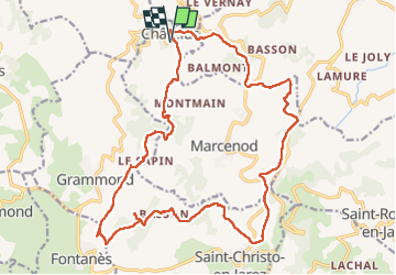

Length
23 km

Max alt
948 m

Uphill gradient
759 m
Km-Effort
34 km

Min alt
656 m

Downhill gradient
761 m
Boucle
Yes
Creation date :
2022-10-12 07:25:07.32
Updated on :
2022-11-30 14:02:06.358
5h47
Difficulty : Medium

FREE GPS app for hiking
 SityTrail
IGN / Geographical institutes
SityTrail Plus
The world is yours!
About
Trail Walking of 23 km to be discovered at Auvergne-Rhône-Alpes, Loire, Châtelus. This trail is proposed by psesjs.
Positioning
Country:
France
Region :
Auvergne-Rhône-Alpes
Department/Province :
Loire
Municipality :
Châtelus
Location:
Unknown
Start:(Dec)
Start:(UTM)
614316 ; 5050047 (31T) N.
Comments