


30 11 22

micheleuvrard
User
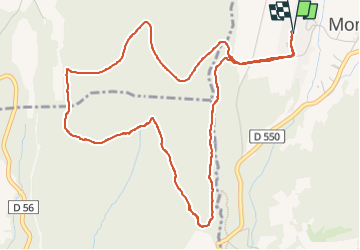

Length
6.4 km

Max alt
336 m

Uphill gradient
109 m
Km-Effort
7.9 km

Min alt
251 m

Downhill gradient
107 m
Boucle
Yes
Creation date :
2022-11-30 13:04:20.809
Updated on :
2022-11-30 15:33:55.753
2h28
Difficulty : Medium

FREE GPS app for hiking
 SityTrail
IGN / Geographical institutes
SityTrail Plus
The world is yours!
About
Trail Walking of 6.4 km to be discovered at Auvergne-Rhône-Alpes, Drôme, Montjoyer. This trail is proposed by micheleuvrard.
Photos

Positioning
Country:
France
Region :
Auvergne-Rhône-Alpes
Department/Province :
Drôme
Municipality :
Montjoyer
Location:
Unknown
Start:(Dec)
Start:(UTM)
646871 ; 4926506 (31T) N.
Comments