


Les hauts de Dineault

cron
User

Length
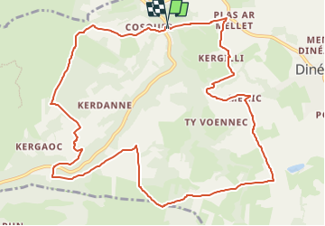
12.6 km

Max alt
182 m

Uphill gradient
326 m
Km-Effort
16.9 km

Min alt
29 m

Downhill gradient
320 m
Boucle
Yes
Creation date :
2022-11-30 16:56:17.511
Updated on :
2022-11-30 16:57:29.903
3h50
Difficulty : Easy

FREE GPS app for hiking
 SityTrail
IGN / Geographical institutes
SityTrail Plus
The world is yours!
About
Trail Walking of 12.6 km to be discovered at Brittany, Finistère, Dinéault. This trail is proposed by cron.
Description
parking au Cosquer, carrefour des 5 chemins sur la D47.
Positioning
Country:
France
Region :
Brittany
Department/Province :
Finistère
Municipality :
Dinéault
Location:
Unknown
Start:(Dec)
Start:(UTM)
411167 ; 5342059 (30U) N.
Comments