


Camp Poincenot à Mirador Cerro Torre

GOHIER
User
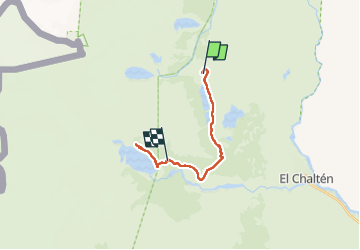

Length
15.3 km

Max alt
808 m

Uphill gradient
346 m
Km-Effort
20 km

Min alt
561 m

Downhill gradient
467 m
Boucle
No
Creation date :
2022-11-29 11:37:51.0
Updated on :
2022-11-30 19:36:52.16
9h15
Difficulty : Medium

FREE GPS app for hiking
 SityTrail
IGN / Geographical institutes
SityTrail Plus
The world is yours!
About
Trail Walking of 15.3 km to be discovered at Santa Cruz Province, Argentina. This trail is proposed by GOHIER.
Description
Sublime
Positioning
Country:
Argentina
Region :
Santa Cruz Province, Argentina
Department/Province :
Unknown
Municipality :
Unknown
Location:
Unknown
Start:(Dec)
Start:(UTM)
648559 ; 4538805 (18F) S.
Comments