


la Grand'Vallée - Saint-Laurent-en-Gâtines via PRs - 26.8km 225m 5h35 (35mn) - 2022 12 03

Orcal37
User GUIDE
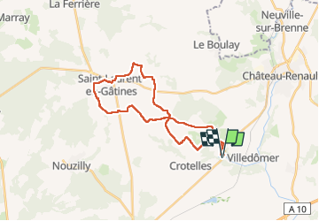

Length
27 km

Max alt
170 m

Uphill gradient
227 m
Km-Effort
30 km

Min alt
90 m

Downhill gradient
227 m
Boucle
Yes
Creation date :
2022-12-03 09:59:02.918
Updated on :
2022-12-04 11:53:55.089
5h35
Difficulty : Medium

FREE GPS app for hiking
 SityTrail
IGN / Geographical institutes
SityTrail Plus
The world is yours!
About
Trail Walking of 27 km to be discovered at Centre-Loire Valley, Indre-et-Loire, Villedômer. This trail is proposed by Orcal37.
Description
la Grand'Vallée - Saint-Laurent-en-Gâtines via PRs - 26.8km 225m 5h35 (35mn) - 2022 12 03
Photos
 - 2022 12 03 - Photo 1")
 - 2022 12 03 - Photo 2")
 - 2022 12 03 - Photo 3")
 - 2022 12 03 - Photo 4")
Positioning
Country:
France
Region :
Centre-Loire Valley
Department/Province :
Indre-et-Loire
Municipality :
Villedômer
Location:
Unknown
Start:(Dec)
Start:(UTM)
339162 ; 5268214 (31T) N.
Comments