


Saint hilaire de court

lecmic
User
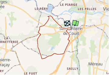

Length
12 km

Max alt
144 m

Uphill gradient
112 m
Km-Effort
13.5 km

Min alt
97 m

Downhill gradient
110 m
Boucle
Yes
Creation date :
2022-12-04 06:56:03.126
Updated on :
2022-12-04 09:22:04.858
2h07
Difficulty : Very easy

FREE GPS app for hiking
 SityTrail
IGN / Geographical institutes
SityTrail Plus
The world is yours!
About
Trail Walking of 12 km to be discovered at Centre-Loire Valley, Cher, Saint-Hilaire-de-Court. This trail is proposed by lecmic.
Description
téléthon
Positioning
Country:
France
Region :
Centre-Loire Valley
Department/Province :
Cher
Municipality :
Saint-Hilaire-de-Court
Location:
Unknown
Start:(Dec)
Start:(UTM)
426092 ; 5228430 (31T) N.
Comments