


à.gerville l"orchet

RoMo
User
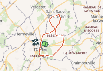

Length
11.3 km

Max alt
135 m

Uphill gradient
90 m
Km-Effort
12.5 km

Min alt
106 m

Downhill gradient
88 m
Boucle
No
Creation date :
2022-11-20 07:58:08.743
Updated on :
2022-12-06 19:06:37.564
2h22
Difficulty : Easy

FREE GPS app for hiking
 SityTrail
IGN / Geographical institutes
SityTrail Plus
The world is yours!
About
Trail Walking of 11.3 km to be discovered at Normandy, Seine-Maritime, Angerville-l'Orcher. This trail is proposed by RoMo.
Description
boucle st sauveur

Positioning
Country:
France
Region :
Normandy
Department/Province :
Seine-Maritime
Municipality :
Angerville-l'Orcher
Location:
Unknown
Start:(Dec)
Start:(UTM)
303561 ; 5496097 (31U) N.
Comments