


toto

Liebeaux
User
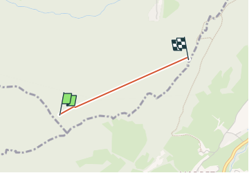

Length
1.4 km

Max alt
1090 m

Uphill gradient
160 m
Km-Effort
3.3 km

Min alt
955 m

Downhill gradient
105 m
Boucle
No
Creation date :
2022-12-08 09:02:45.763
Updated on :
2022-12-08 09:30:26.754
24m
Difficulty : Easy

FREE GPS app for hiking
 SityTrail
IGN / Geographical institutes
SityTrail Plus
The world is yours!
About
Trail Walking of 1.4 km to be discovered at Auvergne-Rhône-Alpes, Isère, Goncelin. This trail is proposed by Liebeaux.
Positioning
Country:
France
Region :
Auvergne-Rhône-Alpes
Department/Province :
Isère
Municipality :
Goncelin
Location:
Unknown
Start:(Dec)
Start:(UTM)
734277 ; 5022660 (31T) N.
Comments