


versigny

gr-gd
User

Length
16.7 km

Max alt
98 m

Uphill gradient
109 m
Km-Effort
18.1 km

Min alt
68 m

Downhill gradient
101 m
Boucle
No
Creation date :
2022-11-24 08:28:00.31
Updated on :
2022-12-08 10:18:34.89
3h58
Difficulty : Very easy

FREE GPS app for hiking
 SityTrail
IGN / Geographical institutes
SityTrail Plus
The world is yours!
About
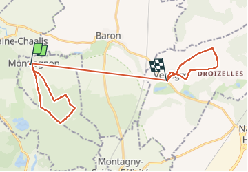
Trail Walking of 16.7 km to be discovered at Hauts-de-France, Oise, Montlognon. This trail is proposed by gr-gd.
Positioning
Country:
France
Region :
Hauts-de-France
Department/Province :
Oise
Municipality :
Montlognon
Location:
Unknown
Start:(Dec)
Start:(UTM)
477607 ; 5445721 (31U) N.
Comments