


toto

Liebeaux
User
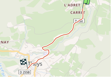

Length
2.2 km

Max alt
776 m

Uphill gradient
4 m
Km-Effort
2.8 km

Min alt
622 m

Downhill gradient
153 m
Boucle
No
Creation date :
2022-12-08 10:52:47.065
Updated on :
2022-12-08 11:16:48.55
23m
Difficulty : Easy

FREE GPS app for hiking
 SityTrail
IGN / Geographical institutes
SityTrail Plus
The world is yours!
About
Trail Walking of 2.2 km to be discovered at Auvergne-Rhône-Alpes, Isère, Theys. This trail is proposed by Liebeaux.
Positioning
Country:
France
Region :
Auvergne-Rhône-Alpes
Department/Province :
Isère
Municipality :
Theys
Location:
Unknown
Start:(Dec)
Start:(UTM)
265551 ; 5022014 (32T) N.
Comments