


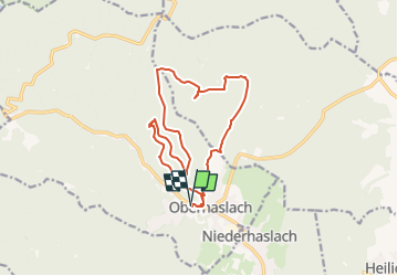
Panorama d'Oberhaslach

vaillantjm
User

Length
14.7 km

Max alt
683 m

Uphill gradient
659 m
Km-Effort
24 km

Min alt
270 m

Downhill gradient
659 m
Boucle
Yes
Creation date :
2022-12-08 20:01:33.668
Updated on :
2023-03-06 09:35:11.896
5h00
Difficulty : Difficult

FREE GPS app for hiking
 SityTrail
IGN / Geographical institutes
SityTrail Plus
The world is yours!
About
Trail Walking of 14.7 km to be discovered at Grand Est, Bas-Rhin, Oberhaslach. This trail is proposed by vaillantjm.
Description
Randonnée très variée : rochers pittoresques, ruines de châteaux, belles forêts. Et en prime, surprenantes et intéressantes sculptures sur le chemin du retour.
Positioning
Country:
France
Region :
Grand Est
Department/Province :
Bas-Rhin
Municipality :
Oberhaslach
Location:
Unknown
Start:(Dec)
Start:(UTM)
376274 ; 5378870 (32U) N.
Comments