


Marche nordique 5

LEDUNC
User
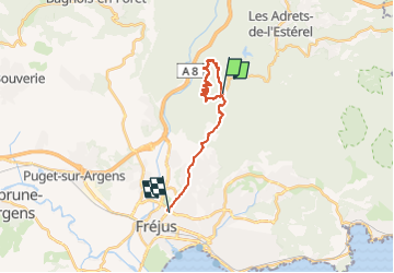

Length
16.7 km

Max alt
228 m

Uphill gradient
269 m
Km-Effort
21 km

Min alt
24 m

Downhill gradient
439 m
Boucle
No
Creation date :
2022-12-10 07:13:35.19
Updated on :
2022-12-12 16:30:43.384
1h58
Difficulty : Easy

FREE GPS app for hiking
 SityTrail
IGN / Geographical institutes
SityTrail Plus
The world is yours!
About
Trail Nordic walking of 16.7 km to be discovered at Provence-Alpes-Côte d'Azur, Var, Fréjus. This trail is proposed by LEDUNC.
Description
Départ du Col de L'Auriasque
Positioning
Country:
France
Region :
Provence-Alpes-Côte d'Azur
Department/Province :
Var
Municipality :
Fréjus
Location:
Unknown
Start:(Dec)
Start:(UTM)
320370 ; 4818008 (32T) N.
Comments