


Pontgibaud La Cheire AR

pidjam
User
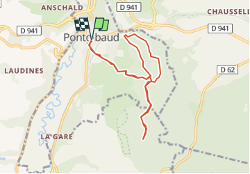

Length
8.5 km

Max alt
782 m

Uphill gradient
163 m
Km-Effort
10.7 km

Min alt
673 m

Downhill gradient
164 m
Boucle
Yes
Creation date :
2022-12-10 10:46:08.238
Updated on :
2022-12-10 10:46:34.845
2h25
Difficulty : Medium

FREE GPS app for hiking
 SityTrail
IGN / Geographical institutes
SityTrail Plus
The world is yours!
About
Trail Walking of 8.5 km to be discovered at Auvergne-Rhône-Alpes, Puy-de-Dôme, Pontgibaud. This trail is proposed by pidjam.
Positioning
Country:
France
Region :
Auvergne-Rhône-Alpes
Department/Province :
Puy-de-Dôme
Municipality :
Pontgibaud
Location:
Unknown
Start:(Dec)
Start:(UTM)
488514 ; 5075411 (31T) N.
Comments