


Grenoble Frange Verte Echirolles

c.gourme
User
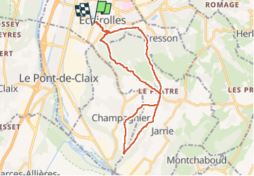

Length
16.7 km

Max alt
444 m

Uphill gradient
394 m
Km-Effort
22 km

Min alt
230 m

Downhill gradient
390 m
Boucle
Yes
Creation date :
2022-12-10 07:59:07.0
Updated on :
2022-12-10 13:37:05.686
5h17
Difficulty : Easy

FREE GPS app for hiking
 SityTrail
IGN / Geographical institutes
SityTrail Plus
The world is yours!
About
Trail Walking of 16.7 km to be discovered at Auvergne-Rhône-Alpes, Isère, Échirolles. This trail is proposed by c.gourme.
Description
Au début ne pas prendre la trace marquée, mais aller chercher à droite le bon chemin.
Positioning
Country:
France
Region :
Auvergne-Rhône-Alpes
Department/Province :
Isère
Municipality :
Échirolles
Location:
Unknown
Start:(Dec)
Start:(UTM)
713483 ; 5002378 (31T) N.
Comments