


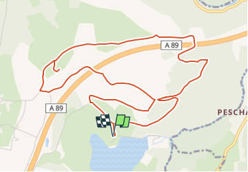
Trail Planner Map

pidjam
User

Length
7 km

Max alt
802 m

Uphill gradient
176 m
Km-Effort
9.3 km

Min alt
668 m

Downhill gradient
176 m
Boucle
Yes
Creation date :
2022-12-10 13:56:55.843
Updated on :
2022-12-10 13:58:02.261
2h07
Difficulty : Medium

FREE GPS app for hiking
 SityTrail
IGN / Geographical institutes
SityTrail Plus
The world is yours!
About
Trail Walking of 7 km to be discovered at Auvergne-Rhône-Alpes, Puy-de-Dôme, Bromont-Lamothe. This trail is proposed by pidjam.
Positioning
Country:
France
Region :
Auvergne-Rhône-Alpes
Department/Province :
Puy-de-Dôme
Municipality :
Bromont-Lamothe
Location:
Unknown
Start:(Dec)
Start:(UTM)
487604 ; 5076853 (31T) N.
Comments