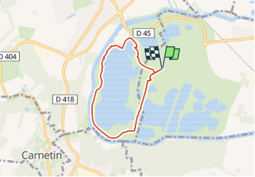
SityTrail - SM_JABLINES_7.6Km

GOELE RANDO
Randonner avec bonne humeur et convivialité. (Inscription réservée uniquement aux animateurs de GOËLE RANDO)


1h16
Difficulty : Easy

FREE GPS app for hiking
 SityTrail
IGN / Geographical institutes
SityTrail Plus
The world is yours!
About
Trail Walking of 5.2 km to be discovered at Ile-de-France, Seine-et-Marne, Jablines. This trail is proposed by GOELE RANDO.
Description
https://www.goelerando.fr/
DAMMARTIN en GOELE 77
Deuxième Parking Gratuit en saison hiver
(https://jablines-annet.iledeloisirs.fr/tarifs-entrees-particuliers.html)
Photos

Positioning
Comments