


Rouen Clochers Oubliés 4.2km

JMCMoreau
User
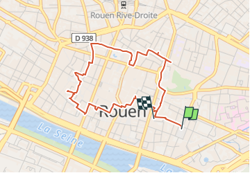

Length
4.2 km

Max alt
33 m

Uphill gradient
40 m
Km-Effort
4.7 km

Min alt
11 m

Downhill gradient
32 m
Boucle
No
Creation date :
2022-12-12 10:20:17.741
Updated on :
2022-12-12 10:20:19.797
3h00
Difficulty : Very easy

FREE GPS app for hiking
 SityTrail
IGN / Geographical institutes
SityTrail Plus
The world is yours!
About
Trail Walking of 4.2 km to be discovered at Normandy, Seine-Maritime, Rouen. This trail is proposed by JMCMoreau.
Positioning
Country:
France
Region :
Normandy
Department/Province :
Seine-Maritime
Municipality :
Rouen
Location:
Unknown
Start:(Dec)
Start:(UTM)
362350 ; 5477989 (31U) N.
Comments