


le rocher des druides

darranger
User
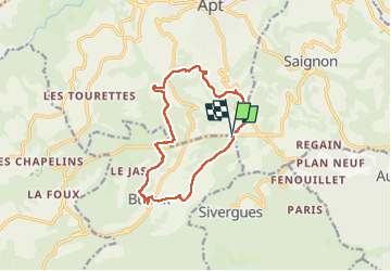

Length
13.5 km

Max alt
566 m

Uphill gradient
393 m
Km-Effort
18.7 km

Min alt
359 m

Downhill gradient
389 m
Boucle
Yes
Creation date :
2022-12-12 09:03:31.694
Updated on :
2022-12-12 14:20:06.545
3h36
Difficulty : Difficult

FREE GPS app for hiking
 SityTrail
IGN / Geographical institutes
SityTrail Plus
The world is yours!
About
Trail Walking of 13.5 km to be discovered at Provence-Alpes-Côte d'Azur, Vaucluse, Buoux. This trail is proposed by darranger.
Positioning
Country:
France
Region :
Provence-Alpes-Côte d'Azur
Department/Province :
Vaucluse
Municipality :
Buoux
Location:
Unknown
Start:(Dec)
Start:(UTM)
693231 ; 4857504 (31T) N.
Comments