


04 - Beynes-MNT

nobir
User
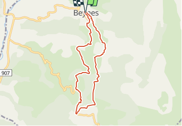

Length
7.8 km

Max alt
942 m

Uphill gradient
240 m
Km-Effort
11 km

Min alt
733 m

Downhill gradient
246 m
Boucle
Yes
Creation date :
2022-12-13 09:57:04.829
Updated on :
2022-12-13 09:59:26.002
2h29
Difficulty : Medium

FREE GPS app for hiking
 SityTrail
IGN / Geographical institutes
SityTrail Plus
The world is yours!
About
Trail Walking of 7.8 km to be discovered at Provence-Alpes-Côte d'Azur, Alpes-de-Haute-Provence, Beynes. This trail is proposed by nobir.
Positioning
Country:
France
Region :
Provence-Alpes-Côte d'Azur
Department/Province :
Alpes-de-Haute-Provence
Municipality :
Beynes
Location:
Unknown
Start:(Dec)
Start:(UTM)
277338 ; 4874602 (32T) N.
Comments