


les orres

Gbreuilh
User
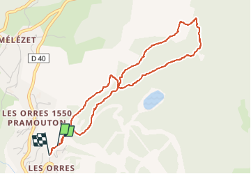

Length
4.9 km

Max alt
1819 m

Uphill gradient
222 m
Km-Effort
7.8 km

Min alt
1629 m

Downhill gradient
222 m
Boucle
Yes
Creation date :
2022-12-13 12:39:37.594
Updated on :
2022-12-13 14:55:11.013
2h14
Difficulty : Medium

FREE GPS app for hiking
 SityTrail
IGN / Geographical institutes
SityTrail Plus
The world is yours!
About
Trail Walking of 4.9 km to be discovered at Provence-Alpes-Côte d'Azur, Hautes-Alpes, Les Orres. This trail is proposed by Gbreuilh.
Positioning
Country:
France
Region :
Provence-Alpes-Côte d'Azur
Department/Province :
Hautes-Alpes
Municipality :
Les Orres
Location:
Unknown
Start:(Dec)
Start:(UTM)
305843 ; 4929848 (32T) N.
Comments