Trail Walking Saint-Amans - Saint amans  - Photo
© OpenStreetMap contributors
Length
Length
7.9 km
Max alt
Max alt
349 m
Uphill gradient
Uphill gradient
226 m
Km-Effort
Km-Effort  
10.9 km
Min alt
Min alt
267 m
Downhill gradient
Downhill gradient
229 m
Boucle
Boucle
Yes
Creation date :
2022-12-13 13:01:34.494
Updated on :
2023-01-04 15:28:30.821

(1 Reviews)

Walking
Walking
1h59
Difficulty : Medium

Scan this QR Code to open this trail in the SityTrail application

FREE GPS app for hiking

Logo SityTrail SityTrail

IGN / Geographical institutes

Download SityTrail from the App Store Download SityTrail from Google Play

Logo SityTrail SityTrail World

The world is yours!

Download SityTrail from the App Store Download SityTrail from Google Play Download SityTrail on Huawei AppGallery

About

Trail Walking of 7.9 km to be discovered at Occitania, Aude, Saint-Amans. This trail is proposed by Mamilaure.

Description

Se garer au village descendre la rue du cimetière et prendre le chemin sur la gauche on revient par la piste de droite
Petite rando agréable passage par de petits sentiers ou chemins dans les bois avec de beaux points de vues facile

Elevation profile

Positioning

Country:
France
Region :
Occitania
Department/Province :
Aude
Municipality :
Saint-Amans
Location:
Unknown
Start:(UTM)
409532 ; 4786753 (31T) N.

Comments

Please log in to post a review or rate the element


Trails nearby

Trail Walking Fonters-du-Razès - Boucle Saint Christol  - Photo
Walking
Mamilaure

Walking

Easy
Fonters-du-Razès, Occitania, Aude, France
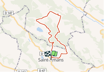
12.6 km | 16.3 km-effort
2h 48min
Yes
Trail Walking Cazalrenoux - cazalrenoux - Photo
Walking
cappelle

Walking

Easy
Cazalrenoux, Occitania, Aude, France
9.5 km | 13.1 km-effort
2h 49min
No
Trail Mountain bike Mayreville - 15° rando de la PIEGE 2009 - Photo
Mountain bike
tracegps

Mountain bike

Difficult
Mayreville, Occitania, Aude, France
34 km | 45 km-effort
3h 30min
Yes
Trail Walking Generville - generville - Photo
Walking
ROLLAND Maryse

Walking

Difficult
Generville, Occitania, Aude, France
9.6 km | 13.2 km-effort
2h 56min
Yes
Trail Walking Cahuzac - poncy - Photo
Walking
cappelle

Walking

Medium
Cahuzac, Occitania, Aude, France
8.3 km | 10.8 km-effort
2h 31min
Yes
Trail Walking Fonters-du-Razès - chapelle saint Christol  - Photo
Walking
Mamilaure

Walking

Medium
Fonters-du-Razès, Occitania, Aude, France
13 km | 16.7 km-effort
3h 22min
Yes
Trail Walking Saint-Amans - st amans - Photo
Walking
cappelle

Walking

Easy
(1)
Saint-Amans, Occitania, Aude, France
7.6 km | 10.5 km-effort
2h 24min
Yes
Trail Walking Cazalrenoux - Sénateurs à Cazalrenoux - Photo
Walking
geli.henri

Walking

Medium
Cazalrenoux, Occitania, Aude, France
6.6 km | 8.9 km-effort
7h 45min
No
Trail Walking Cazalrenoux - Czzarenoux côté Ouest - Photo
Walking
geli.henri

Walking

Medium
Cazalrenoux, Occitania, Aude, France
7.4 km | 10.1 km-effort
1h 46min
No


Close
My subscriptions