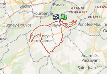
Trail Walking Silley-Bléfond - Silley Blėfond - Photo
© OpenStreetMap contributors
Length
Length
15.8 km
Max alt
Max alt
596 m
Uphill gradient
Uphill gradient
449 m
Km-Effort
Km-Effort  
22 km
Min alt
Min alt
309 m
Downhill gradient
Downhill gradient
451 m
Boucle
Boucle
Yes
Creation date :
2022-12-14 09:49:05.263
Updated on :
2022-12-26 20:04:41.323

(0 Reviews)

Walking
Walking
3h23
Difficulty : Medium

Scan this QR Code to open this trail in the SityTrail application

FREE GPS app for hiking

Logo SityTrail SityTrail

IGN / Geographical institutes

Download SityTrail from the App Store Download SityTrail from Google Play

Logo SityTrail SityTrail Plus

The world is yours!

Download SityTrail from the App Store Download SityTrail from Google Play Download SityTrail on Huawei AppGallery

About

Trail Walking of 15.8 km to be discovered at Bourgogne-Franche-Comté, Doubs, Silley-Bléfond. This trail is proposed by eltonnermou.

Description

parking mairie
Belle randonnée avec de beaux points de vue sur la vallée du Doubs. Le cheminement est parfois difficile, les bâtons sont fortement conseillés.
Dans ces espaces escarpés laissez vous surprendre par la faune sauvage (chamois, chevreuil, ...). Petit bémol, un peu trop de goudron  (et pas assez de plumes) à mon goût.

Elevation profile

Photos

Positioning

Country:
France
Region :
Bourgogne-Franche-Comté
Department/Province :
Doubs
Municipality :
Silley-Bléfond
Location:
Unknown
Start:(UTM)
297862 ; 5244648 (32T) N.


Close
My subscriptions