


GR6 - Russan - Le Pont du Gard (parking)

JackyCouturier
User
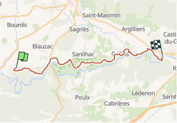

Length
25 km

Max alt
182 m

Uphill gradient
456 m
Km-Effort
32 km

Min alt
19 m

Downhill gradient
527 m
Boucle
No
Creation date :
2022-12-15 14:49:51.961
Updated on :
2023-08-19 12:38:01.114
7h13
Difficulty : Difficult

FREE GPS app for hiking
 SityTrail
IGN / Geographical institutes
SityTrail Plus
The world is yours!
About
Trail On foot of 25 km to be discovered at Occitania, Gard, Sainte-Anastasie. This trail is proposed by JackyCouturier.
Positioning
Country:
France
Region :
Occitania
Department/Province :
Gard
Municipality :
Sainte-Anastasie
Location:
Unknown
Start:(Dec)
Start:(UTM)
606877 ; 4866128 (31T) N.
Comments