Trail Walking Montjoux - 2022-12-16_08h52m12_tmpWriteApidae_48958_fr - Photo

2022-12-16_08h52m12_tmpWriteApidae_48958_fr

 chancha
chancha

User

© OpenStreetMap contributors
Length
Length
6.1 km
Max alt
Max alt
578 m
Uphill gradient
Uphill gradient
169 m
Km-Effort
Km-Effort  
8.4 km
Min alt
Min alt
473 m
Downhill gradient
Downhill gradient
168 m
Boucle
Boucle
Yes
Creation date :
2022-12-16 07:52:12.699
Updated on :
2023-01-02 17:51:13.485

(0 Reviews)

Walking
Walking
1h55
Difficulty : Easy

Scan this QR Code to open this trail in the SityTrail application

FREE GPS app for hiking

Logo SityTrail SityTrail

IGN / Geographical institutes

Download SityTrail from the App Store Download SityTrail from Google Play

Logo SityTrail SityTrail World

The world is yours!

Download SityTrail from the App Store Download SityTrail from Google Play Download SityTrail on Huawei AppGallery

About

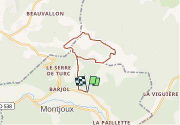
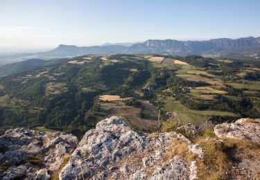
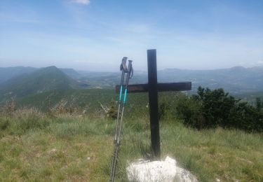
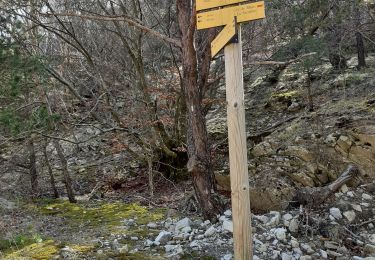
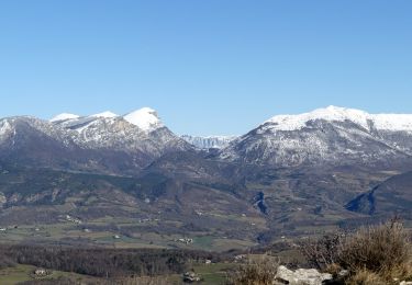
Trail Walking of 6.1 km to be discovered at Auvergne-Rhône-Alpes, Drôme, Montjoux. This trail is proposed by chancha.

Description

Principalement sur piste avec quelques parties un peu techniques, cette petite boucle est très agréable. Idéale pour une sortie en famille, elle côtoie d’innombrables champs de lavande. Non accessible aux poussettes !

Elevation profile

Photos

Positioning

Country:
France
Region :
Auvergne-Rhône-Alpes
Department/Province :
Drôme
Municipality :
Montjoux
Location:
Unknown
Start:(UTM)
667546 ; 4930020 (31T) N.

Trails nearby

Trail Walking Montjoux - Le Devès - Montjoux - Photo
Walking
tracegps

Walking

Easy
(1)
Montjoux, Auvergne-Rhône-Alpes, Drôme, France
5.3 km | 7 km-effort
1h 19min
Yes
Trail Walking Dieulefit - 26 dieulefit chap st Maurice vitrouilleres - Photo
Walking
himba26100

Walking

Easy
Dieulefit, Auvergne-Rhône-Alpes, Drôme, France
13.8 km | 23 km-effort
6h 17min
Yes
Trail Walking Dieulefit - Vitrouillières Dieulefit  - Photo
Walking
alinetpierre

Walking

Medium
Dieulefit, Auvergne-Rhône-Alpes, Drôme, France
14.8 km | 25 km-effort
4h 28min
Yes
Trail Walking Dieulefit - 2022-09-03_11h50m30_Chapelle St Maurice 10km.gpx (3).xml - Photo
Walking
chancha

Walking

Difficult
Dieulefit, Auvergne-Rhône-Alpes, Drôme, France
10 km | 17.1 km-effort
3h 53min
Yes
Trail sport Vesc - Wikiloc - Vesc - Photo
sport
johnw

sport

Very easy
(1)
Vesc, Auvergne-Rhône-Alpes, Drôme, France
8 km | 12.9 km-effort
Unknown
Yes
Trail Walking Vesc - bec de jus - Photo
Walking
Vero7684

Walking

Difficult
Vesc, Auvergne-Rhône-Alpes, Drôme, France
13.6 km | 25 km-effort
5h 51min
Yes
Trail Walking Vesc - bec de jus - Photo
Walking
parastat

Walking

Medium
Vesc, Auvergne-Rhône-Alpes, Drôme, France
5.1 km | 10.9 km-effort
2h 27min
Yes
Trail Walking Dieulefit - Chapelle St Maurice-Col Pertuis 11km - Photo
Walking
GUIDE
thonyc

Walking

Medium
Dieulefit, Auvergne-Rhône-Alpes, Drôme, France
11.4 km | 19.8 km-effort
4h 27min
Yes
Trail Walking Montjoux - Grottes Sarrazines - Photo
Walking
ajd26

Walking

Easy
Montjoux, Auvergne-Rhône-Alpes, Drôme, France
16.2 km | 25 km-effort
5h 5min
Yes


Close
My subscriptions