


Ville Camp de Cesar

pb07
User
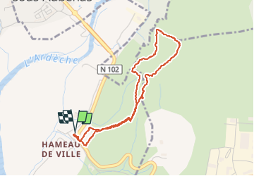

Length
4.1 km

Max alt
365 m

Uphill gradient
188 m
Km-Effort
6.6 km

Min alt
188 m

Downhill gradient
190 m
Boucle
Yes
Creation date :
2022-12-16 14:05:54.551
Updated on :
2022-12-16 15:54:19.28
1h47
Difficulty : Easy

FREE GPS app for hiking
 SityTrail
IGN / Geographical institutes
SityTrail Plus
The world is yours!
About
Trail Walking of 4.1 km to be discovered at Auvergne-Rhône-Alpes, Ardèche, Aubenas. This trail is proposed by pb07.
Positioning
Country:
France
Region :
Auvergne-Rhône-Alpes
Department/Province :
Ardèche
Municipality :
Aubenas
Location:
Unknown
Start:(Dec)
Start:(UTM)
612495 ; 4938952 (31T) N.
Comments