


Lantouy-L'Oule- igue de la calotte Anglars

houbart
User
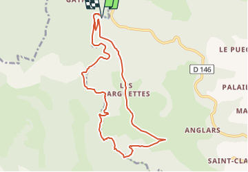

Length
9.7 km

Max alt
331 m

Uphill gradient
221 m
Km-Effort
12.6 km

Min alt
158 m

Downhill gradient
221 m
Boucle
Yes
Creation date :
2022-12-18 09:30:09.052
Updated on :
2022-12-18 09:38:05.816
0m
Difficulty : Very easy

FREE GPS app for hiking
 SityTrail
IGN / Geographical institutes
SityTrail Plus
The world is yours!
About
Trail Walking of 9.7 km to be discovered at Occitania, Aveyron, Salvagnac-Cajarc. This trail is proposed by houbart.
Positioning
Country:
France
Region :
Occitania
Department/Province :
Aveyron
Municipality :
Salvagnac-Cajarc
Location:
Unknown
Start:(Dec)
Start:(UTM)
408523 ; 4923292 (31T) N.
Comments