Trail Nordic walking Gaillac - Vors - Photo
 chripaci
chripaci

User

© OpenStreetMap contributors
Length
Length
10.4 km
Max alt
Max alt
289 m
Uphill gradient
Uphill gradient
270 m
Km-Effort
Km-Effort  
14 km
Min alt
Min alt
173 m
Downhill gradient
Downhill gradient
270 m
Boucle
Boucle
Yes
Creation date :
2022-12-18 08:01:46.0
Updated on :
2022-12-18 12:29:48.439

(0 Reviews)

Nordic walking
Nordic walking
2h16
Difficulty : Medium

Scan this QR Code to open this trail in the SityTrail application

FREE GPS app for hiking

Logo SityTrail SityTrail

IGN / Geographical institutes

Download SityTrail from the App Store Download SityTrail from Google Play

Logo SityTrail SityTrail Plus

The world is yours!

Download SityTrail from the App Store Download SityTrail from Google Play Download SityTrail on Huawei AppGallery

About

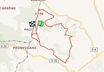
Trail Nordic walking of 10.4 km to be discovered at Occitania, Tarn, Gaillac. This trail is proposed by chripaci.

Description

Vors à partir du parking du Poney club. très belle ballade entre sous-bois et chemins de terre très bien entretenus.
les dénivelés ne sont pas très importants mais sollicite bien le côté "cardio" pour les fans de marche nordique.

Elevation profile

Positioning

Country:
France
Region :
Occitania
Department/Province :
Tarn
Municipality :
Gaillac
Location:
Unknown
Start:(UTM)
407709 ; 4864990 (31T) N.


Close
My subscriptions