


2022-12-18 Picnic CVA Mt Ste Odile a pied

holtzv
User GUIDE
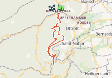

Length
15.7 km

Max alt
788 m

Uphill gradient
612 m
Km-Effort
24 km

Min alt
309 m

Downhill gradient
602 m
Boucle
Yes
Creation date :
2022-12-18 08:30:24.392
Updated on :
2022-12-18 17:06:04.903
4h53
Difficulty : Very difficult

FREE GPS app for hiking
 SityTrail
IGN / Geographical institutes
SityTrail Plus
The world is yours!
About
Trail Walking of 15.7 km to be discovered at Grand Est, Bas-Rhin, Ottrott. This trail is proposed by holtzv.
Photos


Positioning
Country:
France
Region :
Grand Est
Department/Province :
Bas-Rhin
Municipality :
Ottrott
Location:
Unknown
Start:(Dec)
Start:(UTM)
382172 ; 5369425 (32U) N.
Comments