


GR34-EtapeIV-J03

JMCMoreau
User
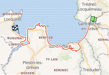

Length
14.4 km

Max alt
100 m

Uphill gradient
306 m
Km-Effort
18.5 km

Min alt
0 m

Downhill gradient
312 m
Boucle
No
Creation date :
2022-12-20 03:06:42.804
Updated on :
2022-12-20 03:07:31.721
4h12
Difficulty : Difficult

FREE GPS app for hiking
 SityTrail
IGN / Geographical institutes
SityTrail Plus
The world is yours!
About
Trail Walking of 14.4 km to be discovered at Brittany, Côtes-d'Armor, Saint-Michel-en-Grève. This trail is proposed by JMCMoreau.
Positioning
Country:
France
Region :
Brittany
Department/Province :
Côtes-d'Armor
Municipality :
Saint-Michel-en-Grève
Location:
Unknown
Start:(Dec)
Start:(UTM)
458270 ; 5392514 (30U) N.
Comments