


GR34-EtapeI-J02

JMCMoreau
User
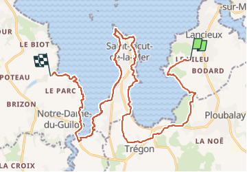

Length
22 km

Max alt
43 m

Uphill gradient
256 m
Km-Effort
26 km

Min alt
0 m

Downhill gradient
242 m
Boucle
No
Creation date :
2022-12-20 17:15:29.361
Updated on :
2023-01-21 17:29:44.393
7h00
Difficulty : Difficult

FREE GPS app for hiking
 SityTrail
IGN / Geographical institutes
SityTrail Plus
The world is yours!
About
Trail Walking of 22 km to be discovered at Brittany, Côtes-d'Armor, Lancieux. This trail is proposed by JMCMoreau.
Positioning
Country:
France
Region :
Brittany
Department/Province :
Côtes-d'Armor
Municipality :
Lancieux
Location:
Unknown
Start:(Dec)
Start:(UTM)
562166 ; 5383181 (30U) N.
Comments