


Cléry l'Ardoux via la butte des élus 2

Rembliere
User

Length
12.7 km

Max alt
102 m

Uphill gradient
78 m
Km-Effort
13.7 km

Min alt
85 m

Downhill gradient
78 m
Boucle
Yes
Creation date :
2022-12-21 08:03:00.009
Updated on :
2022-12-21 11:06:24.414
3h02
Difficulty : Easy

FREE GPS app for hiking
 SityTrail
IGN / Geographical institutes
SityTrail Plus
The world is yours!
About
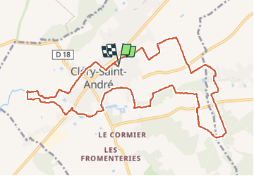
Trail Walking of 12.7 km to be discovered at Centre-Loire Valley, Loiret, Cléry-Saint-André. This trail is proposed by Rembliere.
Positioning
Country:
France
Region :
Centre-Loire Valley
Department/Province :
Loiret
Municipality :
Cléry-Saint-André
Location:
Unknown
Start:(Dec)
Start:(UTM)
407334 ; 5297373 (31T) N.
Comments