


aigle 3,3 309

les randos d'Olivier
partout a pied et en moto
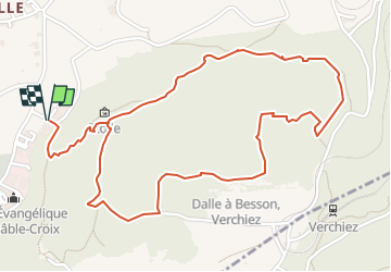

Length
3.3 km

Max alt
661 m

Uphill gradient
309 m
Km-Effort
7.4 km

Min alt
410 m

Downhill gradient
311 m
Boucle
Yes
Creation date :
2022-12-22 08:25:28.785
Updated on :
2022-12-22 08:26:07.723
1h41
Difficulty : Medium

FREE GPS app for hiking
 SityTrail
IGN / Geographical institutes
SityTrail Plus
The world is yours!
About
Trail Walking of 3.3 km to be discovered at Vaud, District d'Aigle, Aigle. This trail is proposed by les randos d'Olivier.
Positioning
Country:
Switzerland
Region :
Vaud
Department/Province :
District d'Aigle
Municipality :
Aigle
Location:
Unknown
Start:(Dec)
Start:(UTM)
343863 ; 5130558 (32T) N.
Comments