


mur de Sologne

lecmic
User
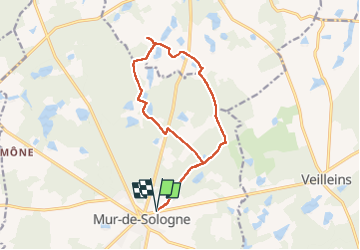

Length
13.6 km

Max alt
134 m

Uphill gradient
106 m
Km-Effort
15 km

Min alt
102 m

Downhill gradient
106 m
Boucle
Yes
Creation date :
2022-12-22 07:31:23.297
Updated on :
2022-12-22 10:39:31.623
3h07
Difficulty : Very easy

FREE GPS app for hiking
 SityTrail
IGN / Geographical institutes
SityTrail Plus
The world is yours!
About
Trail Walking of 13.6 km to be discovered at Centre-Loire Valley, Loir-et-Cher, Mur-de-Sologne. This trail is proposed by lecmic.
Description
rando.
Positioning
Country:
France
Region :
Centre-Loire Valley
Department/Province :
Loir-et-Cher
Municipality :
Mur-de-Sologne
Location:
Unknown
Start:(Dec)
Start:(UTM)
395384 ; 5252079 (31T) N.
Comments