


bois de chazelot

nicolasdresse
User
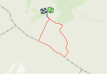

Length
2.7 km

Max alt
441 m

Uphill gradient
62 m
Km-Effort
3.5 km

Min alt
382 m

Downhill gradient
61 m
Boucle
Yes
Creation date :
2018-09-29 20:52:34.783
Updated on :
2018-09-29 20:52:34.792
55m
Difficulty : Easy

FREE GPS app for hiking
 SityTrail
IGN / Geographical institutes
SityTrail Plus
The world is yours!
About
Trail Walking of 2.7 km to be discovered at Bourgogne-Franche-Comté, Haute-Saône, Mailley-et-Chazelot. This trail is proposed by nicolasdresse.
Positioning
Country:
France
Region :
Bourgogne-Franche-Comté
Department/Province :
Haute-Saône
Municipality :
Mailley-et-Chazelot
Location:
Unknown
Start:(Dec)
Start:(UTM)
277320 ; 5266429 (32T) N.
Comments