
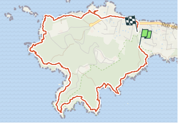
Giens boucle ouest

ego
User

Length
7.1 km

Max alt
95 m

Uphill gradient
237 m
Km-Effort
10.4 km

Min alt
0 m

Downhill gradient
261 m
Boucle
Yes
Creation date :
2022-12-26 10:25:02.053
Updated on :
2022-12-26 17:20:40.873
2h50
Difficulty : Medium

FREE GPS app for hiking
 SityTrail
IGN / Geographical institutes
SityTrail Plus
The world is yours!
About
Trail Walking of 7.1 km to be discovered at Provence-Alpes-Côte d'Azur, Var, Hyères. This trail is proposed by ego .
Photos


Positioning
Country:
France
Region :
Provence-Alpes-Côte d'Azur
Department/Province :
Var
Municipality :
Hyères
Location:
Unknown
Start:(Dec)
Start:(UTM)
264622 ; 4768942 (32T) N.
Comments