


Col du Rousset > Vassieux en Vercors

rafa77
User
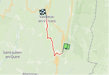

Length
10.2 km

Max alt
1426 m

Uphill gradient
312 m
Km-Effort
15.1 km

Min alt
1056 m

Downhill gradient
525 m
Boucle
No
Creation date :
2022-12-27 11:12:50.291
Updated on :
2022-12-27 11:26:38.658
3h36
Difficulty : Difficult

FREE GPS app for hiking
 SityTrail
IGN / Geographical institutes
SityTrail Plus
The world is yours!
About
Trail Walking of 10.2 km to be discovered at Auvergne-Rhône-Alpes, Drôme, Saint-Agnan-en-Vercors. This trail is proposed by rafa77.
Positioning
Country:
France
Region :
Auvergne-Rhône-Alpes
Department/Province :
Drôme
Municipality :
Saint-Agnan-en-Vercors
Location:
Unknown
Start:(Dec)
Start:(UTM)
690153 ; 4967912 (31T) N.
Comments