


Moulin Beignon ste Flavie des Loups

taguette
User
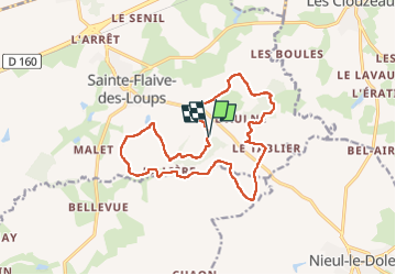

Length
15.8 km

Max alt
76 m

Uphill gradient
110 m
Km-Effort
17.3 km

Min alt
44 m

Downhill gradient
110 m
Boucle
Yes
Creation date :
2022-12-25 09:34:55.162
Updated on :
2022-12-28 13:23:01.334
3h10
Difficulty : Medium

FREE GPS app for hiking
 SityTrail
IGN / Geographical institutes
SityTrail Plus
The world is yours!
About
Trail Walking of 15.8 km to be discovered at Pays de la Loire, Vendée, Sainte-Flaive-des-Loups. This trail is proposed by taguette.
Positioning
Country:
France
Region :
Pays de la Loire
Department/Province :
Vendée
Municipality :
Sainte-Flaive-des-Loups
Location:
Unknown
Start:(Dec)
Start:(UTM)
610705 ; 5161879 (30T) N.
Comments