


Fontvieille tracé Gérard déc 2022

rlebasque
User
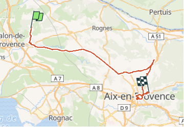

Length
57 km

Max alt
365 m

Uphill gradient
636 m
Km-Effort
66 km

Min alt
85 m

Downhill gradient
628 m
Boucle
No
Creation date :
2022-12-08 13:42:51.102
Updated on :
2022-12-28 15:51:04.738
474h42
Difficulty : Very difficult

FREE GPS app for hiking
 SityTrail
IGN / Geographical institutes
SityTrail Plus
The world is yours!
About
Trail Walking of 57 km to be discovered at Provence-Alpes-Côte d'Azur, Bouches-du-Rhône, Aurons. This trail is proposed by rlebasque.
Positioning
Country:
France
Region :
Provence-Alpes-Côte d'Azur
Department/Province :
Bouches-du-Rhône
Municipality :
Aurons
Location:
Unknown
Start:(Dec)
Start:(UTM)
673790 ; 4836827 (31T) N.
Comments