


Boucle de Congis

katiab
User
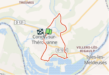

Length
6.1 km

Max alt
68 m

Uphill gradient
46 m
Km-Effort
6.7 km

Min alt
46 m

Downhill gradient
46 m
Boucle
Yes
Creation date :
2022-12-29 13:14:04.059
Updated on :
2022-12-29 14:51:20.967
1h37
Difficulty : Very easy

FREE GPS app for hiking
 SityTrail
IGN / Geographical institutes
SityTrail Plus
The world is yours!
About
Trail Walking of 6.1 km to be discovered at Ile-de-France, Seine-et-Marne, Congis-sur-Thérouanne. This trail is proposed by katiab.
Positioning
Country:
France
Region :
Ile-de-France
Department/Province :
Seine-et-Marne
Municipality :
Congis-sur-Thérouanne
Location:
Unknown
Start:(Dec)
Start:(UTM)
498131 ; 5428221 (31U) N.
Comments