


2023-01-05-rennemoulin

Rando MLC
User
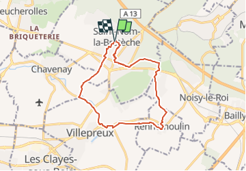

Length
12.6 km

Max alt
145 m

Uphill gradient
138 m
Km-Effort
14.5 km

Min alt
80 m

Downhill gradient
139 m
Boucle
Yes
Creation date :
2022-12-30 10:21:43.185
Updated on :
2022-12-30 10:22:29.048
3h17
Difficulty : Medium

FREE GPS app for hiking
 SityTrail
IGN / Geographical institutes
SityTrail Plus
The world is yours!
About
Trail Walking of 12.6 km to be discovered at Ile-de-France, Yvelines, Saint-Nom-la-Bretèche. This trail is proposed by Rando MLC.
Positioning
Country:
France
Region :
Ile-de-France
Department/Province :
Yvelines
Municipality :
Saint-Nom-la-Bretèche
Location:
Unknown
Start:(Dec)
Start:(UTM)
428105 ; 5412646 (31U) N.
Comments