


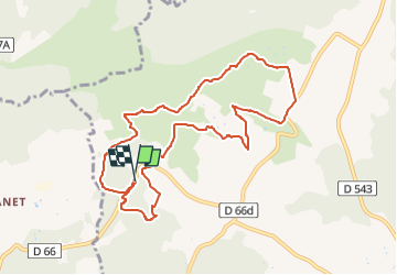
Caïre val - Font de Val - Albert 2

Berpav
User

Length
10.2 km

Max alt
368 m

Uphill gradient
225 m
Km-Effort
13.2 km

Min alt
209 m

Downhill gradient
226 m
Boucle
Yes
Creation date :
2022-12-30 14:10:35.217
Updated on :
2022-12-30 14:12:00.649
3h00
Difficulty : Difficult

FREE GPS app for hiking
 SityTrail
IGN / Geographical institutes
SityTrail Plus
The world is yours!
About
Trail Walking of 10.2 km to be discovered at Provence-Alpes-Côte d'Azur, Bouches-du-Rhône, Rognes. This trail is proposed by Berpav.
Positioning
Country:
France
Region :
Provence-Alpes-Côte d'Azur
Department/Province :
Bouches-du-Rhône
Municipality :
Rognes
Location:
Unknown
Start:(Dec)
Start:(UTM)
686113 ; 4838972 (31T) N.
Comments
bien
cool